When it Rains it Pours: Research and Resilience in North Vietnam
By Yana Dinkelmeyer, Sydney Young
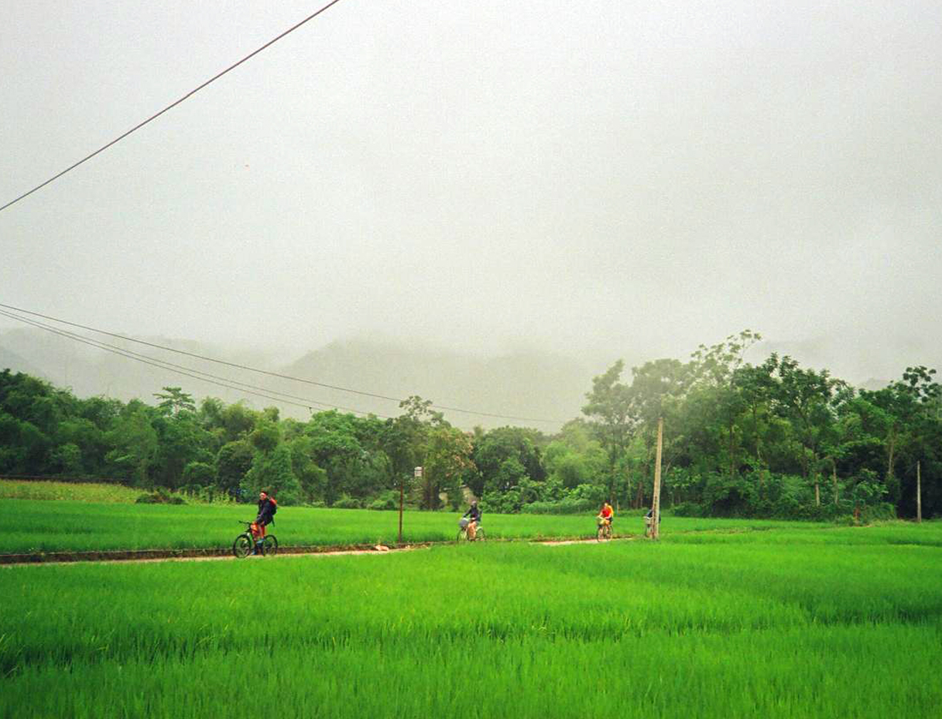
On our way to the next sampling location. © SUSDEV
General description
Amid dark skies and airport shutdowns, our arrival in Hanoi for the start of the Living Lab was overshadowed by super typhoon Yagi—the strongest storm to hit the region in decades— which had passed directly through the city just the night before our group met at a hotel. Despite our several weeks of preparation to study water quality in Vietnam, it was the water falling and flooding from the typhoon that left us reeling and uncertain about what lay ahead. Our goal was to assess the impact of different land-use types—natural, agricultural, and urban—on water quality in the Hoa Binh region, but we hadn’t anticipated contending with the effects of a typhoon. While the damage visible to us was limited to fallen trees on the streets, Yagi continued its path toward the Northwest, crossing our destination, Hoa Binh province, where it brought heavy rains, elevating the risk of landslides and flash floods.
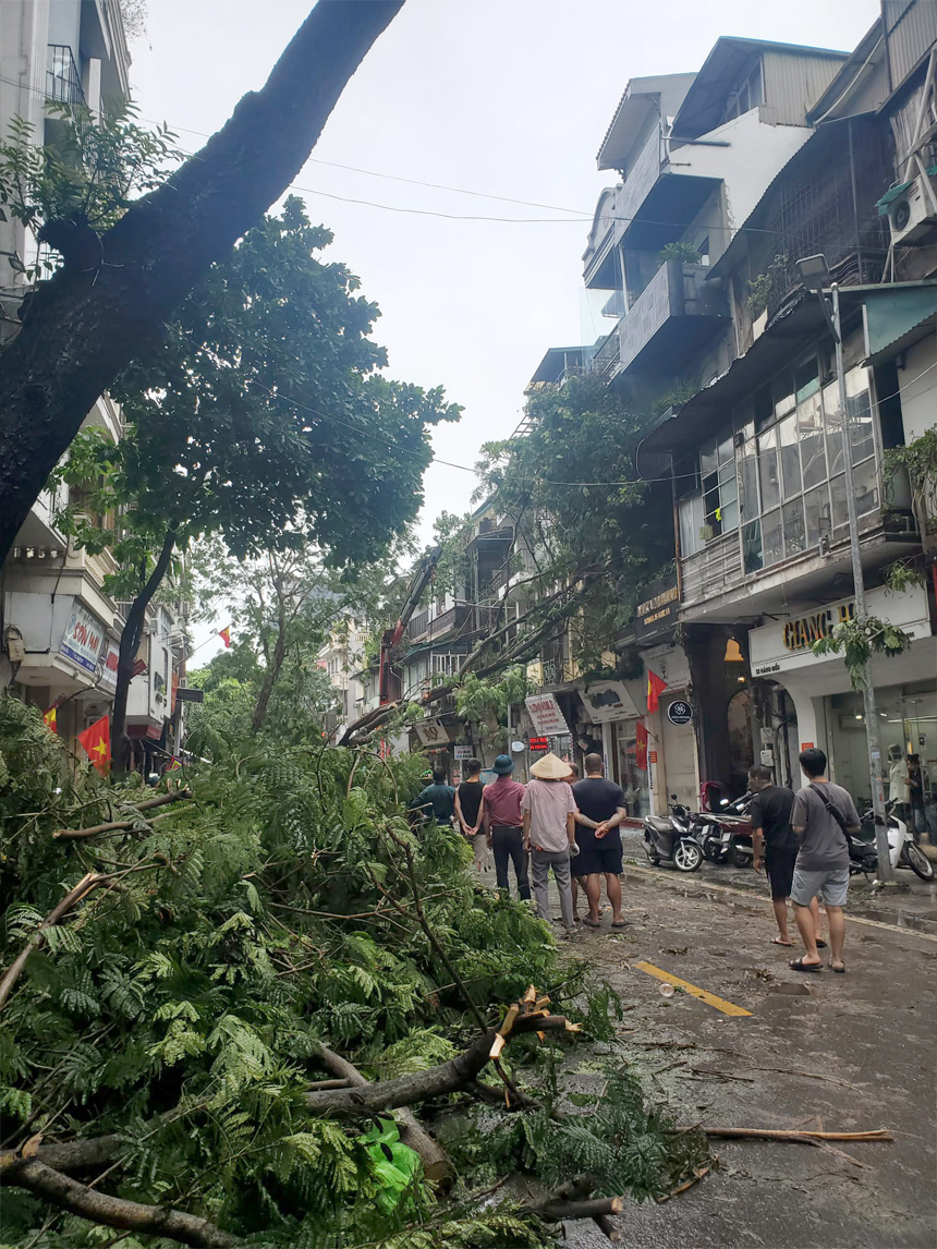
Streets of Hanoi the morning after Yagi. © SUSDEV
Learnings
The following day, as we drove to Mai Hich, we felt apprehensive about the conditions we would encounter in the village. Fortunately, we arrived to a beautiful sunny afternoon and breathtaking landscapes; the region had been spared the worst of Typhoon Yagi, allowing us to proceed with our sampling activities as planned. Our sampling took place across 17 sites in the Hoa Binh province, covering areas categorized by different land uses as natural, agricultural, and urban. By sampling different sites along these land-use gradients, we aimed to capture variations in water quality, including key indicators like pH, dissolved oxygen, and nutrient levels, to understand how human activities impact aquatic ecosystems in this tropical region.
Studying water quality in rapidly growing regions like Hoa Binh is crucial, as urbanization and agricultural expansion can directly affect local ecosystems and biodiversity. This research provides insights into how land use changes influence water quality, helping to address Sustainable Development Goals (SDGs) such as SDG 6 on Clean Water and Sanitation and SDG 15 on Life on Land by identifying areas for improvement in water management and ecosystem protection. By understanding these impacts, we can support efforts to maintain clean water resources and safeguard biodiversity, which are essential for sustainable growth in areas like Hoa Binh.
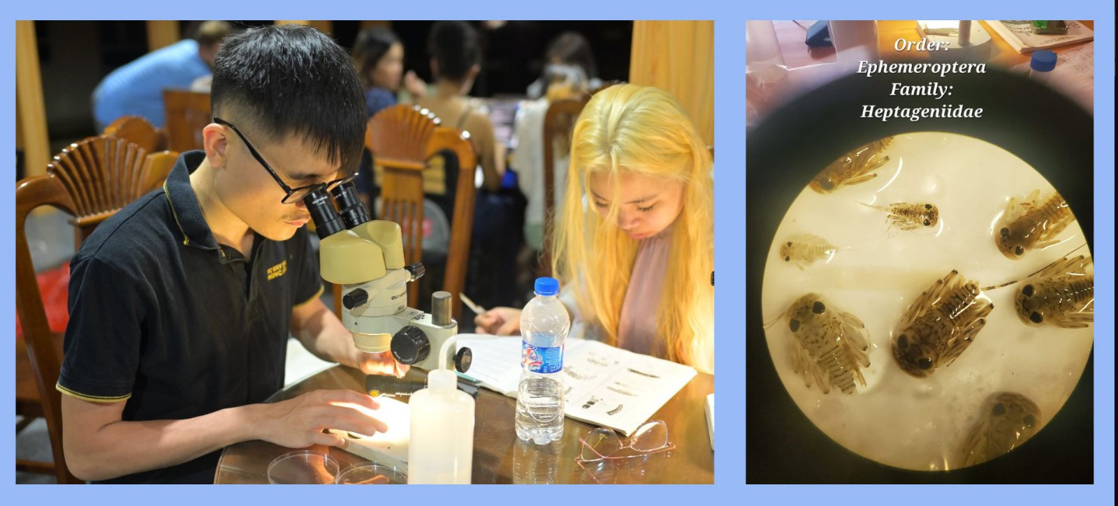
During the Living Lab, our water group was joined by two wonderful Vietnamese students, Chi and Tu, who were invaluable additions to our team. They provided essential support in sampling, interpreting the data, and assisting with GIS mapping, helping us navigate both the technical aspects and local nuances of the fieldwork. On the first day of sampling, our supervisors, Professor Son and Rani, guided us through the process of collecting abiotic measurements and finding macroinvertebrates. We used the kick-sampling technique, which involves disturbing the substrate by “kicking” it while holding a hand net downstream to capture the dislodged organisms. This technique is effective for sampling macroinvertebrates across various habitats, like streambeds, plant roots, and submerged vegetation, allowing us to collect a diverse range of organisms from various micro-habitats.

The thorough collection of all macroinvertebrates from the sample required time, patience, a very good eye and calm hands. © SUSDEV
Macroinvertebrates serve as key indicators of water quality due to their sensitivity to pollution. By calculating the Multimetric Macroinvertebrate Index (MMI), which considers metrics like taxa richness and the presence of pollution-sensitive species such as mayflies, we gained insights into the cumulative effects of environmental stressors over time. A higher MMI score typically reflects better water quality, as pollution-sensitive species thrive in cleaner water, while lower scores indicate pollution or other stressors impacting the presence and abundance of aquatic life.
General experience
While we were able to continue with our activities as planned, other regions of northern Vietnam were not as fortunate. Typhoon Yagi had brought continuous, heavy rains, leading to floods and landslides that severely impacted communities. As foreigners, we received only superficial, and oftentimes conflicting, information about these disasters, not fully grasping their magnitude or the consequences they imposed on local lives. And despite our extensive preparation, we also hadn’t considered how the aftermath of such an intense weather event could impact our data collection. Flooding and landslides can change water quality by washing in extra nutrients and sediments, as well as disturbing macroinvertebrate populations, making it hard to get a true picture of normal conditions. Knowing our samples were possibly influenced compared to last year by the storm’s aftermath reminded us of the challenges of fieldwork in unpredictable conditions and the importance of considering local context when interpreting our data.
Furthermore, our days were packed with work and intense experiences from 7am to 11pm or longer. There was not much time or energy to think about anything further than our little universe in Mai Hich. Yet, for the Vietnamese students and volunteers, the impact went beyond possibly affected data—they were dealing with the serious aftermath affecting their own communities. Some of their families and homes were directly affected by Yagi’s destruction. Others were simply able to read the Vietnamese news which were devastating. While we were happily taking our water samples, Yagi and its aftermaths had killed at least 321 people, injured many more, cut off regions from civilization and help and burried whole villages under landslides.
– Hearing the news, I felt a mix of helplessness and sadness. After spending a year studying the causes of climate change and the rising frequency of extreme weather events, confronting its effects firsthand was sobering. Yet, despite this reality, there was surprisingly little we could do to help—and it was all too easy to set those thoughts aside, focusing instead on our scientific pursuits. It was the second time for me that I was in a region which was hit by a disaster. And it was the second time for me that I was barely affected by it while less fortunate people around me lost their normalcy and their livelihoods, and sometimes, their lives. And like the first time, I was appalled by how easy it was to ignore a disaster happening around you if it does not affect you directly. And while this time the people most strongly affected by the disaster were many kilometers away, I sometimes wondered if it was ignorant and selfish to carry on with our sampling collection under these circumstances. –
Yana
– Even though I was off-site, working on this Living Lab project was incredibly enriching. Through in-depth documentation and literature review, I could anticipate some of the challenges my group members might face—especially with Typhoon Yagi’s potential impact on our samples. While I couldn’t be there in person, I felt connected to the fieldwork through their photos, which let me appreciate the beauty of this part of the world and provided insight into the practicalities of our sampling. –
Caroll
These connections deepened as we began analyzing our preliminary findings, which hinted at general trends, like natural sites showing slightly better water quality indicators. However, our statistical analysis didn’t reveal significant differences across land-use types. The typhoon’s disruptive effects, combined with overlapping water quality indicators across natural, agricultural, and urban sites, likely influenced our results, making it harder to identify clear patterns. For example, nutrient and sediment runoff from the storm may have raised nutrient levels in all areas, causing water quality readings that were unexpectedly similar between different land uses. This further restricts what we can extrapolate from our data and adds an extra layer of complexity when considering the reliability of our results, a factor that is openly and thoroughly discussed in our report.
Despite the additional questions raised by our research, we gained valuable insights into the intricate relationship between land use, water quality, and human impact. This understanding enables us to engage meaningfully with global sustainability goals by helping to pinpoint areas where conservation efforts can be focused and where improvements in land and water management are needed to protect vital resources. Even with challenges and uncertainties, each step brings us closer to aligning our fieldwork with a larger vision for sustainable development.
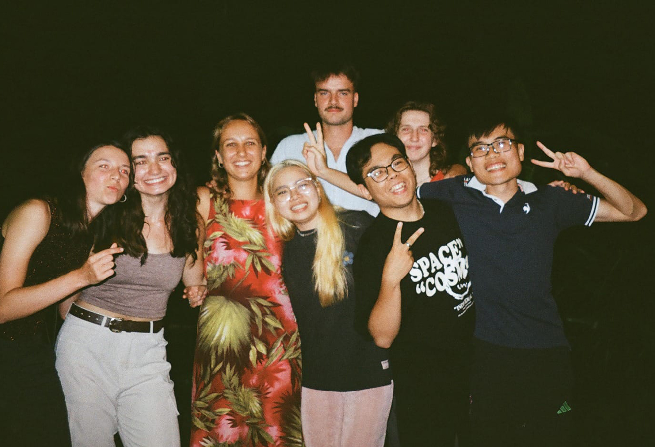
Our beautiful water group. © SUSDEV